Fire in the Australian Landscape in Context


REFERENCES (Links to documents)
Please check the file size will match your internet download speed & allowance!
- Cape Liptrap Coastal Park prescribed burn. - 0.4Mb
- Observations of vegetation at Walkerville. - 0.4Mb
- Report to the Minister: A Request for a Pause of Planned Fires, Cape Liptrap Coastal Park. - 0.8Mb
- Wildlife Research- lyrebirds and fire, Nugent et al. 2014
- Problems with control Burning NPA Bulletin
- Shedding Light on Lepidoptera, Ecos article "Champions of Science, Dr Ian Common" - 2mb (large file)
- Oecophorinae genera of Australia, Common, 1994 Introduction vol 1, (Moth Biology)
- Scientific advice that the DEPI took on powerful owls until Friday May 15th 2014
- 2013 Report - Impact of Planned Burn - 2.1Mb (large file)
- The Land Conservation Council Report on South Gippsland 1982 - 0.7Mb
- Is the loss of Australian digging mammals contributing to a deterioration in ecosystem function? - 0.5Mb
- Aerial Photo - 0.9Mb
- A letter from an ex Priest from Fish Creek in 1926 - 0.7Mb
- Cape Liptrap Management Plan - 0.8Mb
- Dusky Antichinus (Marsupial Mouse), Cape Liptrap - 0.5Mb
- Kirkstall euro grass conversion - A project to replace highly flammable European grass with Native Grasses - 1.4Mb
- Walkerville Lime Kilns and abalone - a letter from Great Southern Star Leogatha 1918 - 0.4Mb
- Report of the Bushfire Review Committee 1983 - 216 pages, 60Mb (large file)
- Victorian Western District Gunditjmara Linguist, Joel Wright, speaks from language and historic references to Aboriginal use of fire - not what people expect and highly informative
Pause and Review Burning.
Gammage's popular book 'The Biggest Estate on Earth: How Aborigines Made Australia' contains many fundamental flaws and represents 'blind advocacy' for repeated burning' because 'Aboriginal people did it'. Like Keith Windshuttle's 'Fabrication of Aboriginal History', Bill Gammage only pursued references - and interpretation of references - that supported his 'hypothesis'...More.
An Opportunity to Look Before We Burn
Fire safety starts with preventing fires being lit, detecting them and putting them out rapidly. The idea of burning the bush is to reduce fuel loads and severity of future fires – but it does not always work which is why wet bush is not subjected to planned fire. Planned burning may also be counterproductive in damp coastal forests like those in Cape Liptrap Coastal Park between Walkerville and Waratah Bay.
As a community we have put foresters and others in charge of fire and pressured them to stop future deaths from bushfires like that those which occurred on Black Saturday. The 2009 Bushfires Royal Commission was announced before the death toll was known and long before the fire was out. It charged six foresters and one zoologist with ensuring future fire safety through fuel reduction burning.
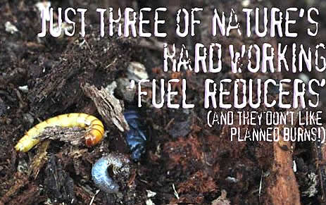
This management is being used by foresters – and now many botanists – is to burn the bush and stop flammable fuel accumulation. Other scientists have identified a range of species that breakdown leaves and timber at a rate that increases steadily after fire events such as the specialist eucalypt leaf eating caterpillars. These tiny insects, the adults recently identified as ‘mallee moths’, have a huge diversity reflecting the fine leaf fuels they consume and they build into unimaginably vast numbers in litter beds.
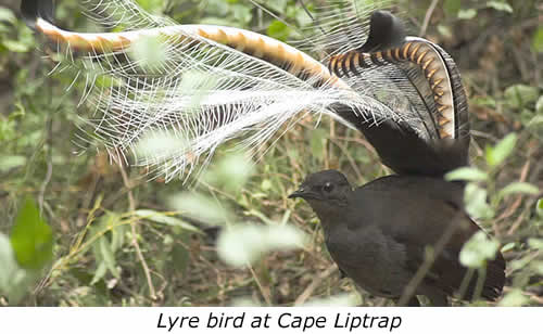
Scientists have also discovered lyrebirds live on these insects, turning over litter and twiggy fuels, virtually ‘composting them’ to encourage these insects that they then feed on. As coastal forest ages and its canopy closes the wind speed within it drops and it cools growing rainforest species and a vast variety of ferns. It likely becomes less flammable.
Other species like wood eating termites and fungi also build up into vast numbers, but like ‘mallee moths’ in damp bush, they are all but lost in diversity and abundance when the bush they live in is burned. Ferns and fern gullies are lost too and the forest opened up by fire (and ‘fire breaks’) dried out, likely becoming more flammable.
At Walkerville there have been heathlands on the sandy ridges for millennia which have built up layers of peat in the soils which now store vast amounts of water and supporting perched swamps which feed this water to the fern gullies below.
This kind of environment can best protected by rapid detection and effective response to fires, the control of feral animals that eat ferns and less flammable plants like deer and rabbits and predators like foxes that eat the leafing eating animals and birds.
This may well be the reason that this particular bush has not burned for nearly 90 years. A group of locals, scientists and naturalists have initiated research projects in the forest between Walkerville and Waratah to identify the species that play a key role in fuel reduction.
You can also make donations (see donations link) to support these projects and keep updated on their progress through this website, facebook and youtube
Donations to help the fight
The Eclectic Parrot Website is being redeveloped to address Issues related to fire in the Australian landscape. Starting with an outline of a particular issue with proposed burning for Cape Liptrap Coastal Park - for which we are seeking a Moratorium. The website will be developed over time and a reference documents that can be downloaded will be listed at the top of this page.
We need a bit of financial help with printing & advertising so, if you can, please send any donations to The Natural History Network:
Direct Deposit to ANZ Bank account - NHN BSB (013 259) Account (2952 34401)
Or
Cheques to - Natural History Network,
c/- PO Box 305,
Foster VIC 3960
LETTERS
Dr. Marianne Horak is curator of the Lepidoptera collection at the Australian National Insect Collection.
To whom it may concern,
Whilst responsible for Lepidoptera (moths and butterflies) at the Australian National Insect Collection at CSIRO Ecosystem Sciences (formerly CSIRO Entomology) I have during the last 10 years repeatedly suggested that it would be crucial to do research into the effects of the widespread control burning on mallee moths (Oecophoridae), whose larvae are the major agent of eucalypt leaf litter break-down. Hence I’m delighted that such a study is now being considered at the Cape Liptrap Coastal Park, finally providing a scientific underpinning for decisions on fire management as far as leaf litter break-down by mallee moths is concerned, and I would like to give my full support to this endeavour. Obviously, a moratorium on currently planned burning is a precondition for any such study to be possible.
Unlike in northern hemisphere temperate forests and in tropical rain forests the leaf litter in the Australian myrtaceous forests is to a large extent broken down by the small caterpillars of the mallee moth family (Oecophoridae), which live in the various leaf litter layers and also feed on loose dead leaves still on twigs or on the ground. This group of moths, usually numbering a few hundred species in any fauna, has radiated to the tune of 5000 species in Australia after managing to colonise living and then dead myrtaceous leaves, both nutritionally challenging substrates. About 25% of all Australian Lepidoptera species are mallee moths, which clearly demonstrates their ecological importance.
While we know from a lifetime of collecting experience that recently or, worse, frequently burned forests have very low numbers and diversity of mallee moths, we have only few observations of actual caterpillar numbers in the leaf litter. However, what we have suggests that the larvae can reach very high densities: Plowmann 1979: 438 Lepidoptera larvae per m 2 of leaf litter in wet sclerophyll forest; I F B Common pers. comm.: 54-252 Lepidoptera larvae in casual leaf litter samples (ca. 130 g dry weight) at Depot Beach, NSW. There can be no doubt that such numbers mean a huge reduction of leaf litter as anybody can infer who observes the relatively sparse layer of eucalypt leaf litter in a mature and undisturbed forest, compared to the build up of leaves in eucalypt forests recently burned or in eucalypt plantations overseas. As a certain humidity is required for larval feeding the oecophorid caterpillars are mostly active in winter, which also happens to be the time of control burning, inflicting the largest possible damage on the oecophorid population. This means that the post burning leaf fall will not be broken down until the area is recolonised by moths from unburnt areas. Whilst it is becoming acknowledged that frequent burning encourages exactly those plants such as introduced grasses that will make fire even more of a hazard, the quiet work of leaf litter break-down by oecophorid moths (and of wood by termites and beetles) has still not gained the necessary attention.
I emphatically add my voice to the call for a moratorium on prescribed burning for the Cape Liptrap Coastal Park until meaningful studies on leaf litter accumulation and break-down have been done. Together with my colleague Ted Edwards I’m very willing to advise and help set up research into mallee moth populations with regard to fire management. As far as mallee moths are concerned, there is a comprehensive revision of the Australian Oecophoridae available and we now have the molecular tools to make such research possible.
With best wishes, Marianne Horak
Dr Tim Flannery is one of Australia's best-known scientists as well as being one of our best-selling writers.
"Burning programs such as that proposed for the Walkerville portion of the Cape Liptrap Coastal Park need to factor in predator control, weed spread and fires likely impact on fuel loads. In the absence of effective programs and research in these areas burning may cause more harm than good. I would therefore oppose this planned burning until these factors are addressed by research and management. This site is unique and provides an important opportunity to study the role of insects, other fauna and fungi in reducing flammable fuel loads.
Best wishes, Tim Flannery"
James Bowler well known Australian Scientist who has worked both in Archeology and Paleontology as a Dr. and Professor and now AM.
I write as a person with a long interest as involved observer in the application of fire to land management. Many years of experience in the drier regions of inland Australia, often with Indigenous owners, stand in contrast to that of my youth, own home ground at Leongatha and current residence in the rainforest country of Foster, specifically Grady's Ridge Road.
My long involvement with archaeology and the development of my colleague, the late Rhys Jones’ fire-stick farming hypothesis, has remained contentions outside the specific areas of its justifiable application.
One point of recent concern involves the widespread influence of the splendid but seriously flawed book of Bill Gammage, “The First Estate”. While indigenous application of fire has long been documented in the drier regions of inland Australia and some parts of more temperate grasslands, the relevance of fire-stick ecology in the rainforests has been seriously misinterpreted by Gammage. The application of the fire ecology model based on the Gammage book is therefore seriously flawed, at least in its application to the high rainfall areas of the continent.
It has come to my attention that plans to burn the rainforest reservation near Waratah Bay are currently under consideration. Until such time as a detailed ecological database has been defined to justify such action any immediate application of reduction burning would have inevitable long-term consequences.
Such intended action could well be turned into positive advantage by using this occasion to carry I would be grateful if you could supply me with current details of such ecological data sets.
Such intended action could well be turned into positive advantage by using this occasion to carry out the level of ecological survey these particularly sensitive coastal environments demand. Such regions, of high diversity and environmental sensitivity are especially attractive to a widerange of the community concerns. They therefore deserve highest levels of scientifically-based management as justification for future strategic planning. I would be grateful if you could supply me with current details of such ecological data sets.
Until management can provide details of the complex biological and physical diversity, any plans for fuel reduction burning should be on hold.
Yours sincerely
James M. Bowler AM
640 O’Gradys Ridge Rd.
Foster 3960
A Moratorium on Prescribed Burning
for the Coastal Park on Waratah Bay 2014
The real fire threat for communities on Waratah Bay are grass fires from north and the unmanned camping ground at Bear Gully with inadequate firefighting facilities. It is important that there be a moratorium on planned ‘Prescribed Burns’ for Waratah Bay section of Cape Liptrap Coastal Park until the likely impact of such a fire is determined by research. It could dry the bush, increase dead solid timber fuel load and open up vegetation to increased wind speed, drying and increased fire risk. A prescribed burn could also escape as other burns have recently.
Fires, even those often described as ‘cool burns’, always kill insects and fungi that play a key role in rotting down solid timber fuel. They also kill reptiles, frogs, nestling birds and many small mammals, especially young native animals in nests and smaller adults like pygmy possums; the animals this Coastal Park was set up to protect in 1982.
The Coastal Park along Waratah Bay contains a mosaic of moist, wet, south facing fern gullies on ancient dunes and a now isolated population of lyrebirds. Its intact catchments all flow from the Cape Liptrap Ridge to the sea. It was originally set aside by local farmers as a Park for locals and holiday makers escape the north winds, summer heat and enjoy the sheltered coast.
A Vital Research Opportunity
The impact of proposed burns on the fungi and insects that reduce fuel loads, wildlife and vegetation can be determined by comparing like bush burned at different times in the past. This Coastal Park has been subjected to a number of small accidental, fuel reduction and ecological burns over the last two decades. This history, plus what local people can add to it, provides the opportunity to compare the impact of fire on the same or similar vegetation with the same aspect and soil. Wind speed, solid timber fuel loads and the abundance of fungi, termites and the flammability of the regrowing vegetation, all unique to Cape Liptrap Coastal Park, can be compared. There is no evidence of any burning of this landscape by Aboriginal people.
Origin of this Planned Prescribed Burning
The 2009 Bushfire Royal Commission recommended the systematic fuel reduction burning of 5% all crown lands, including National Parks. Where fire will likely increase fuel loads it was clearly not intended to be used. However there is not as yet a resourced capacity to determine this beyond simple basic generalised assessments of bark and litter that ignore fuel reduction capacity of termites, other insects and fungi etc. The likely impact of fire on that capacity and abundance of flammable plants like bracken are vital to know before burning. The grass fire risk from road reserves and farmland to the north needs to be considered and managed too.
When Prescribed Burns Increase Fuel Loads
A ‘Fuel Reduction Burn’ lit in a forest near WTree in East Gippsland in 2009 actually increased the fuel loads. Victoria’s Chief Fire Officer at the time, Ewan Waller, interviewed on ABC Radio Sale on September 1st in 2010 agreed with the caller and stated it was a wider problem. In this instance large amounts of dead timber cleared from local road reserves was taken to an area of old wet forest and ignited to start the burn;
‘…Charlie: Yes Ewan look, we’ve got um, fuel reduction burning happening north of us at W Tree, we’re finding that um, some of the burns are actually um, increasing, um, solid fuel loads on the forest floor you know, we’re getting some very hot burns, canopy scorch and stuff like that, trees falling down ah, whole tree heads and whole trees and…and actually the…there’s more fuel on the forest floor after these ah burns and this is creating a fire hazard you know, and a threat to our community
EW: It’s… a good point Charlie and , I think it’s a product because a lot of these areas we haven’t burnt for a long while and actually when we’re now burning them they’ve got heavy fuel loads, a lot of old dead trees or not dead trees but trees on the way out and actually when we do burn they then fall over, drop branches and whatever and I…what I’m looking for in the monitoring and I think this is probably important is that when we go back and burn those areas again, are we actually changing the structure of the forest back to what probably it should be which is a lot less of those, you know, moribund type trees and ah, we’ll end up getting less fuel but I agree, I’ve noticed the same, there’s been a lot of timber coming down after these trees and I think it’s probably a product of drought ah, not being burnt for a long while, heavy fuel loads, fire goes through and a lot comes to the ground…’
If the Chief Fire Officer was given the opportunity to liaise with CSIRO entomologists and mycologists (insects and fungi scientists) he may have been more circumspect in regard to his comments. The Coastal Park on Waratah Bay has a wet southerly aspect and though it has likely been struck by lightning repeatedly since it last big fire in 1927 the only fires that have needed to be extinguished were ignited by people.
Old Bush is Harder to Burn
The principle fire threat to these communities adjacent to Waratah Bay is from the rising slopes through farmland to the north and flammable introduced grass species along roads.
If a fire starts on the coast the mosaic of wet fern gullies falling southeast from the Cape Liptrap Ridge would deny any fire a clear run to populated areas. A fire from the north would slow as it goes downhill and would also have to get through the same wet gullies.
Termites are spreading with hundreds of mounds throughout this Park breaking down solid timber fuel loads. A large range of fungi species in the Park are also breaking down dead timber. This Park has not had a major wildfire or caught fire from any lightning strikes for more than 80 years and is less likely to as it gets older and wetter.
This is consistent with records from Stan Stanfield interviews with older locals Charlie Nicoll about his grandfather Bill Nicoll’s accounts of settling Fish Creek from 1888 in the 1960’s;
‘…(It was) very different to what we have now, the fact was then the only thing getting grass established was to ring bark the big timber, cut the scrub and sow grass on the ashes. Well he has often said his big problem was to get enough wind – there was no wind to get through the forest at all. It was not until the railways was opened and the contract was cut right through the damp forest, a strip of three chain wide... all timber was removed… those days (with the) cost of labour at six shillings day, it was cheaper to bury the timber than burn it and much of that timber from Fish Creek to Hoddle was buried … mother used to describe it as just being like columns, a wall of timber either side and the little black stumps that were left…(that) had to be cut down to a minimum of 3 feet – represented the (clearance of) vehicles of the time. That was the first means of letting a draft through the forest … he was here four years before he could get any wind to burn a fire, and he always said he was here four years too soon…’
Fire Risk Mitigation
If these prescribed burns proceed it is essential that all property owners are notified which has not happened when these burns have been previously delayed. People including adjacent farmers, must be given an opportunity change their holiday arrangements, to be present and plan for the possible defense of their properties. Few residents knew of last proposed burn in early 2013 at 11 pm the night before – a burn that was fortunately called off the next day.
Parks Victoria and DEPI lit fires escaped on Snake Island and Mount Margaret on Wilson’s Promontory in 2000 and 2005 when fires burned for three weeks. In 2009 another fire on Wilson’s Promontory was prolonged by relighting for nearly 60 days. Heavy rain in 2010 led to $millions damage from subsequent erosion and Park closure for 6 months. A 2013 burn near Mirboo North escaped burning over 800 hectares of public and private land, fences and sheds.
Planning for sufficient resources to contain fire
Despite talks and meetings regarding the proposed burn over the last 12 months some locals were confused as to what area was actually going to be burned at the time of writing. Other locals and property owners have been actively excluded from meetings or not notified. Local understanding where fires will be lit, when, what resources will be available to contain it etc. is vital. It must also be clear what firefighting resources are available for any burn and to deal with rats, snakes etc, escaping fires into neighbouring properties.
Potential Ecological Impacts
There is the risk of the loss of powerful owls, an isolated population of lyrebirds and small mammals to fire, post fire predation and the impact of fallow deer, rabbits and foxes. This fire will also reduce the capacity of the wet heath to maintain its aquifers (water table) that feed wet fern gullies, the swamps behind the beach and the springs that flow onto it long after rain.
Enhanced Rapid Fire Detection and Response Capacity for Waratah Bay Communities
- Construct a Viewing Platform to generate tourism and funds and to establish thermal imaging cams for 24 h fire season surveillance north and south of the Cape Liptrap Ridge, from Waratah to Cape Liptrap. A Viewing Platform with web accessible cam recorders for surf and whales etc. can also generate funds for the local CFA.
- Staff Parks Victoria Bear Gully Camping Ground for the Fire Season and upgrade its firefighting capacity to the equivalent of the Walkerville North Camping Ground.
How can you help?
Come down as a tourist and see and take photos of insects, fungi and existing vegetation to add to the exiting bank of over 3000 photos and create a record. Other things you can do;
- Send photos to [email protected] or use www.wetransfer.com for larger files to create a comprehensive record against which the impact of any fire can be seen
- Be a tourist and enjoy this unique park and contribute to the local economy
- Provide contact details to be informed of workshops with naturalists and local Aboriginal people to learn about how different types of bush respond fire.
- Write and indicate your willingness to pay to visit a viewing/fire tower to raise funds to keep the park and its communities safe from fire and support the local CFA.
Write letters of support for research into the natural capacity of this bush to break down fuel loads and the likely impact of fire on that capacity. Write and ask that no fires are lit until independent research is completed showing fire will not increase fuel loads and flammability of the existing vegetation to:
- Peter Mc Ewan District Manager Land & Fire ( new Latrobe Region) (([email protected])
- Graeme Baxter Parks Victoria District Manager (([email protected])
- and cc your letters to your local state members – upper and lower house, http://www.parliament.vic.gov.au/members to pass to the appropriate Minister.
- Please send copies of emails, letters & replies to [email protected] or PO Box 305 Foster 3969.
![]()